
 .
.
. |
 |
|
.
 .Baltimore's Harbor - Circa
1860 .
|
By the 1800's, Baltimore's
harbor was one of the most popular ports on the East Coast.
The port's activity helped to give Baltimore a strong industrial
base , and the City grew quickly over the years.
Postcards above show the Light Street activity of
Baltimore.
|

|
.
 |
.. 
|
............... 
|
Scenes of the commerce
along the waterfront, as the Harbor developed. Above views
are of Light Street over the years. Below, a few looks
at the Northern border, Light Street in postcards over
the years................................................

..............
 Pratt Street, Baltimore Maryland 1912.
|
|
|
| A look at a ship coming
in the harbor around the 1920's, carrying watermelon, likely
from the Eastern Shore of Maryland. The water in
Baltimore's harbor was never all that clean, with
spoiled produce often thrown overboard from ships and boats
and left rotting in the water.Below, Oyster boats
unload. |
.
 |
 |
| Postcard Right
: Rare view looking East out of the Harbor, likely taken
from the area of the old McCormick Spice Building. The
scene shows the old steamboats
that would up and down the Chesapeake Bay. This
view is likely from the 1900's. Below are several
early postcard views of the Baltimore Harbor, circa around
1900. |
.
 |
.
 |
.
|
.
 |
..
 . .
Early Light Street
Pier shot, before the great Baltimore Fire.
|
.

.Baltimore's Harbor,
circa 1913
|
.....  ................................. .................................
.Baltimore Harbor
around 1912
|
..
 |
.
 |
.
 |
.
 |
The pictures, to
the above left and above right , are common of what
would be seen in the harbor around the 1920's. City
Hall can be seen in the rear right of the picture, indicating
this picture was probably taken around the area of
today's Maryland Science Center.
.
 Baltimore Harbor
around 1912
|
..
 |
.
 |
 Baltimore's
Light Street piers, circa 1912 ( above ) and
1919 ( below ) .

.
 |
.
 .Baltimore's
Harbor view, circa 1912, above and below.
.
 |
.

.

Above - Baltimore
Harbor circa late 1920's.
Below - here are several
different views from the Federal Hill area north towards
the City Skyline. In the shot to the right , you can clearly
see the Pepsi Cola plant that was located on Key Highway.
These photos date from about 1900 to the 1940's.
|
.
 |
. .
 |
.
 |
.
 |
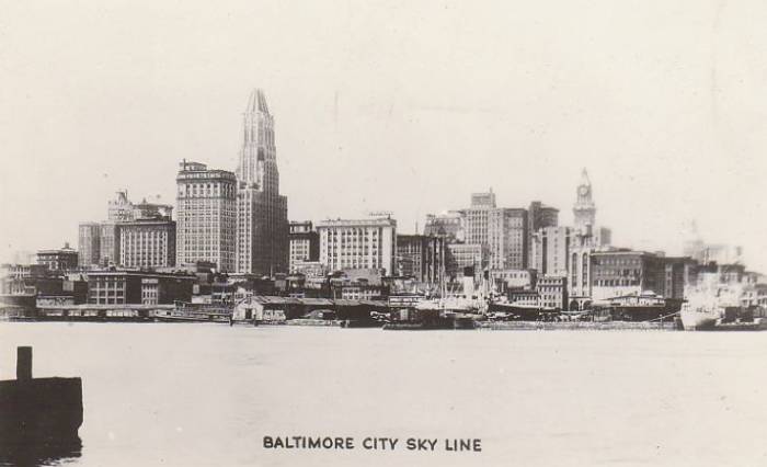
| A 1930's view of the Harbor shows a
steamboat traveling east out into the Bay. The skyline in
the picture shows a Baltimore just beginning to come about.
The tallest building in this picture, the Tower Building,
was torn down in the 1980's. |

|
 |
|
|
.
 ...................................................................................Photo
of the Harbor from around 1935
|

.1949
|

.IND Yearbook - 1949
Cruise
|

|
| Above,
a yearbook photo from the Reporter ( University of
Baltimore Yearbook ) dated 1949. |
| Looking north on Light
Street, probably around the 1940's. Baltimore's docks
and wharfs were still very active and Light Street was
full on shipping activity and markets. Much of the water
in this view was later filled in to create the bulkhead
for Sam Smith Park, which was later built into Harbor
Place. The buildings directly on the lower left of the
postcard have been replaced by a Hyatt Regency Hotel.
|
 ... ... ... ... . In these photos and
old postcards , you can see the skyline slowly beginning
to progress. The smaller buildings on the waterfront have
all long been replaced, except for the power plant building,
which is currently used as a restaurant and attractions.
To the far right of the photos, you can see the dome of
Baltimore's City Hall, and just to the left of that,
the Tower Building. Below are several old postcards of
the City Skyline that Kilduff's has collected. . In these photos and
old postcards , you can see the skyline slowly beginning
to progress. The smaller buildings on the waterfront have
all long been replaced, except for the power plant building,
which is currently used as a restaurant and attractions.
To the far right of the photos, you can see the dome of
Baltimore's City Hall, and just to the left of that,
the Tower Building. Below are several old postcards of
the City Skyline that Kilduff's has collected. |
| ................................. |
.
|
.
 |
.
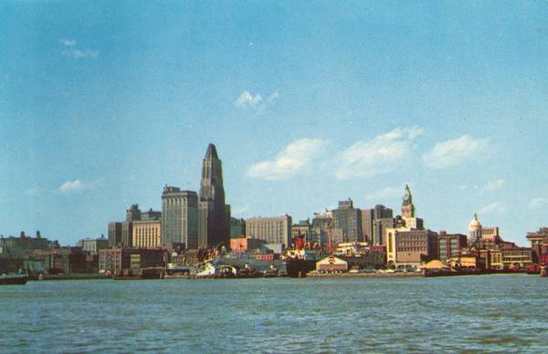 |
......... Long before Baltimore
came up with the Inner Harbor concept and Harborplace,
Baltimore's waterfront was a working harbor, complete
with piers, docks and steamboats. The postcard view
on the right shows the Harbor in the early 1960's,
with a surviving steamboat at Pier One, and a freighter
docked in front of the old News American Building .
Today 's view , seen below and below right
, of the same location show the Harborplace complex
and the Baltimore Aquarium. .....................
.........................................................
 |
.
|
.

.1940's
|
.
|
.
 |
As Baltimore's docks
and wharfs were being used less in the 1950's, the Harbor
area began to show it's age. Below are several pictures
of the Harbor in the 1950's.

.Pratt Street @ Gay
Street - Baltimore : 1950's
|
..
 1950's
|
.
 1953
|
 1953
|
 1957
|
.

.Back in the 1950's,
a large model was made of the Harbor, as seen above. We
have heard that the model still exists and we are making
plans to get pics ! e
|
| .By the 1960's, change
was finally coming to the City, as a large part of the
center of the City was torn down to make way for Charles
Center. |
.

.Demolition - 1964
for Charles Center.
|
.
 1962
|
..
 1960's
|
..

.Harbor - 1964 -
University of Maryland Yearbook - Terrapin
|
.......... .................. 1964 plans for the
Inner Harbor ( above ) , in which the highways
going by ( I-83 and I-95 ) , make the harbor more of a
lagoon. Below, the plans don't include any highways, but
the 1950's plan ( below ) had filling in much of
the harbor and building out into the water more from
the Northern coastline.
.

.
 Yet another plan for the Inner Harbor.
It appears to show two planes in the water, the plan
being that a seaport would have been part of the Harbor
plan.
.Below,
these 1960's plans have very little harbor view from
the area, with buildings surrounding the harbor.
.
 
.
 .Plans
for the bridge that was to cross the Inner Harbor
|
....... ..
..
 |

|
..
1960's view of
Baltimore " Inner Harbor " looking north on Light Street
from Key Highway .
......................
.Below, Pratt Street
in the 1960's - Notice the two way traffic pattern back
then.

.1960's - Pratt Street
- Baltimore Sun Photo
|
| Below,
Baltimore's Inner Harbor, just before the Inner Harbor
plans were developed. |
. 
.Baltimore's Harbor
- Pre Inner Harbor Development
|
.
 1970's
|
.
 Late
1960's - 1970's
|
...
 1970's
|
.
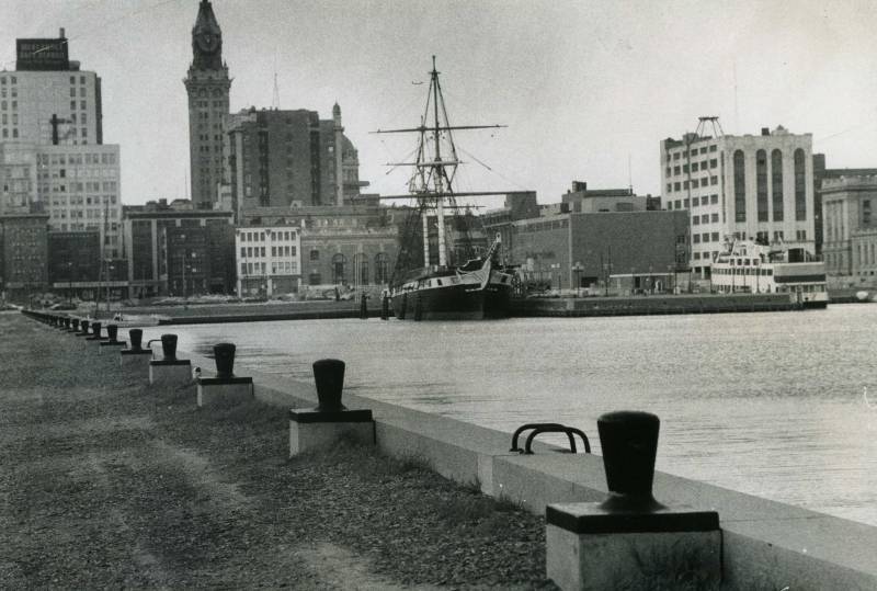
 One of Baltimore's
first Inner Harbor attractions was the Maryland Science
Center, which has grown since this shot was taken back
in the 1970's.
|
Baltimore's Inner
Harbor - Current Years
.

.

.

.
 |
. 
. For more on Baltimore
old cruise and steamboat lines - click the link above.
|
|
. 
Much of the Inner
Harbor shore is being developed. Area like Federal Hill
and Fell's Point have seen a lot residences going up. |
 .....................................................
